In the LandXML/DEM Model Generator, you determine which parts of your land development data are imported to 3ds Max. 3ds Max then creates separate objects for each of the land features, including terrain surfaces, road alignments, and parcels.
Interface
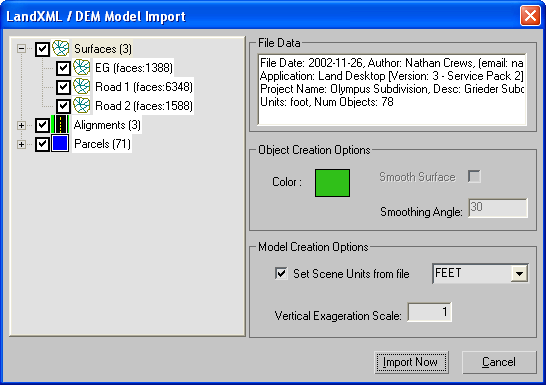
- Object List
-
Lists the terrain surfaces, alignment data, and parcel data in the file to be imported. You can toggle the import of individual
objects or entire groups with their corresponding check boxes.
Three types of civil engineering data stored in LandXML files are supported:
- 3D TIN ground and finished surface model. Terrain surface data is imported to 3ds Max as an editable mesh.
- 2D road centerlines. Alignment data is imported to 3ds Max as a Shape object.
NoteDEM and DDF files do not contain Alignment data.
- 2D legal parcel or lot boundaries. Parcel data is imported to 3ds Max as a Shape object.
NoteDEM and DDF files do not contain Parcel data.
Note2D Alignment and Parcel shapes are created on top of the highest terrain surface.
File Data group
The File Data group displays information about the file to be imported, including date of creation, author, the application
used to create the file, and the units.
Object Creation Options group
The Object Creation Options group lets you set the import properties for selected objects.
- Color
-
The color of the object when it is imported into 3ds Max. To change this setting, click the color swatch and select a new color from the Color Selector.
- Smooth Surface
-
Applies smoothing to the geometry, based on the Smoothing Angle setting. Edges between faces that have an angle between them
that is greater than the specified smoothing angle will appear faceted in the scene. Edges between faces that are below or
equal to the specified angle are smoothed.
NoteThis option is only available for terrain surface objects.
- Smoothing Angle
-
Determines the size of the smoothing angle.
NoteThis option is only available for terrain surface objects.
Model Creation Options group
- Set Scene Units from file
-
Changes the 3ds Max Scene Unit to match the units of the incoming file.
NoteThis setting is only available when the 3ds Max scene is empty. If there is geometry in your scene, this setting is not available.
The units setting of the incoming file is displayed in the drop-down list.
- Vertical Exaggeration Scale
-
Artificially exaggerates the terrain surface to enhance subtle details by applying a scale factors to the vertical dimensions.
TipThis can be useful for very flat surface models.


 Command entry:
 Application menu
  Import