Creates terrain objects from contour line data. You select editable splines representing elevation contours and 3ds Max creates a mesh surface over the contours. You can also create a "terraced" representation of the terrain object so that each level of contour data is a step, resembling traditional study models of land forms.
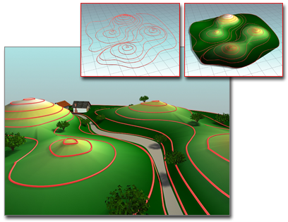
Using contours to build a terrain
Inset left: The contours
Inset right: The terrain object
Main: Terrain object used as the basis of a landscape
When you import an AutoCAD drawing file to use as contour data, 3ds Max names each object based on the AutoCAD object's layer, color, or object type. 3ds Max appends a number after each name. For example, an AutoCAD object on the layer BASE becomes BASE.01.
After importing the contour data, selecting the objects and clicking the Terrain button, 3ds Max moves all the selected objects out of the scene and into the terrain object. Other splines in the selection are treated in the same way as by the Move copy method. You can only use these splines as operands of the terrain object. This is appropriate if you create splines in order to create a terrain object and have no further use for them.


